Masar picks up where it stops. Every visitor gets a turn by turn route from the entrance to the exact room they need, on their own phone. They scan a QR code and walk. No app to download, no hardware to install.
Masar is built by Astravale, an IT services company in Amman. Its first version was built for the Jordan Airline Training & Simulation Center.
Arabic for a path: the route something takes from where it is to where it is going.
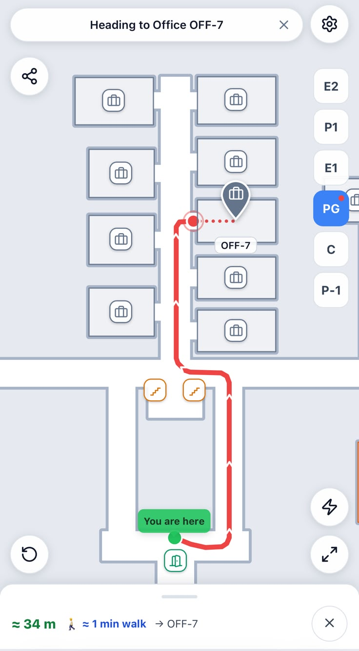
Masar draws a visitor a real route from where they are standing to the room they need, turn by turn, across floors. Not a list of room numbers and not a static map on a wall.
No hardware to install
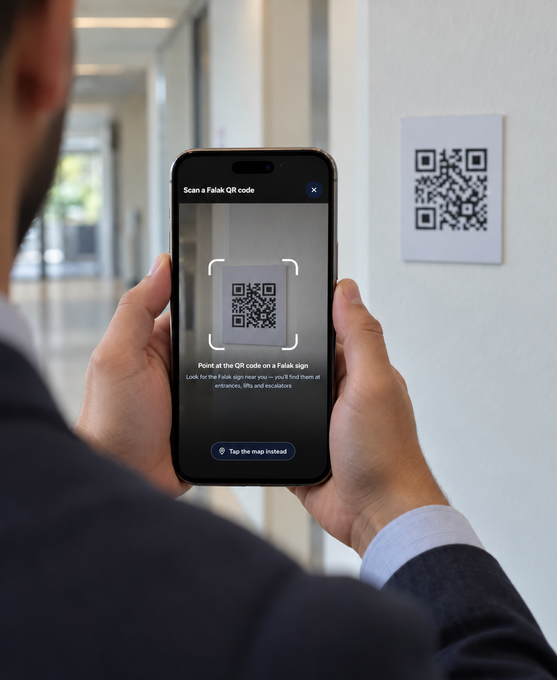
Visitors scan a QR code at an entrance or a corridor junction to set their starting point. No beacons, no wiring, no ceiling work, nothing to buy and mount.
Routes that follow the building
The route is calculated over a grid traced from the real floor plan. Because the walls are part of that grid, a route cannot cut through one.
Every floor, every visitor
Routing across floors through stairs and lifts, with step free routes for wheelchair users, parents with strollers and anyone carrying something heavy.
Runs inside your existing app
Masar is delivered as a web view that drops into a mobile app you already have, or runs on its own in a browser. There is no second app to publish.
Maps we keep current for you
When a wing opens or a room is renamed, send us the change and we update the map. Nobody on your side has to learn a tool, and it costs nothing extra.
One platform, many venues
Built for multiple venues from day one. Each venue keeps its own maps, its own data and its own access rules.
Works alone or inside your app
Masar runs on its own through the QR codes, so you can launch without touching anything you already have. If you do run your own app, we integrate it so navigation sits inside the app your people already use.
See how people move
Every search and route is a signal. You learn which places people look for most, where they start from, when the building is busiest and where visitors get lost, so you can fix the signage, the layout or the staffing.
What it costs
A one time setup fee covers mapping your building. After that it is an annual licence that includes hosting, support, updates and map maintenance. Both are priced by size, so a single building costs a fraction of a full campus. Pilots start with one building, and you see Masar running on your own floor plan before you pay anything.
What it looks like
Two screens from the live system.
Set your position
A visitor scans the code at the entrance and the map knows exactly where they are.
Follow the route
The path is drawn on the real floor plan, with floor changes marked along the way.
Where Masar is being deployed
In progress
Jordan Airline Training & Simulation Center
Training centre, Amman October 2025 to present
Multi building site QR codes, no app Staff and trainees
We built a full application for JATS, and indoor navigation was the part of it that became Masar. We ran the work end to end: requirements gathering and staff interviews, design, development and testing. The system is built and we are now in deployment with the centre.
QR anchored navigation across the centre's buildings
Routing calculated over the real floor plans, floor to floor
Maps the centre's own content and layout changes flow into
Current status: in deployment at the centre on the commercial Masar platform.
In progress
Princess Sumaya University for Technology
University campus, Amman 2026 to present
Campus wide QR codes, no app Managed map updates
A campus wide deployment of Masar, offered to PSUT as a founding partner ahead of general launch. Students and visitors scan a QR code posted around campus and the map opens in their browser. Nothing to install, and no change to any system the university already runs.
Current status: the university has seen the system and wants it. We are scheduling a meeting with university management to agree pilot scope and terms.
How a pilot starts
One building, one floor plan, no commitment past the pilot. Here is the whole process.
Step 1
A short meeting
Thirty minutes to walk through where people get lost in your venue and what you want Masar to solve.
Step 2
A demo on your floor plan
Send us one floor plan. We map it and show you live routing through your own building, not a generic sample.
Step 3
Pilot in one building
We map the building, print and place the QR anchors, and put it in front of real visitors.
Step 4
Roll out the rest
Once the first building is live and your team is happy with it, we map the remaining buildings and take on the map maintenance from there.
Common questions
Do we need to install any hardware?
No. Masar positions people with printed QR codes placed at entrances and corridor junctions. There are no beacons, no sensors and no wiring, so there is nothing to procure, mount or maintain, and nothing to rip out if you stop using it.
Do our visitors have to download an app?
No. Masar runs in the browser. If you already have a mobile app, it drops inside it as a screen. If you do not, scanning the QR code opens the map directly.
What do we need from you to get started?
Floor plans for the building, in any format you have them, and one person we can ask questions. That is enough for us to map a floor and show you routing through your own building.
Who updates the map when the building changes?
We do, and it is included in the licence. Send us the change and we update the map. You do not need to learn a tool, assign someone to it, or budget for it separately.
Is our data separate from other venues?
Yes. Every venue has its own maps, its own data and its own access rules. Nothing is shared between venues.
Can we see it working before we commit?
Yes, and we would prefer that. Send one floor plan and we will map it and show you Masar routing through your own building, at no cost.
Send us one floor plan
We will map it and show you Masar routing through your own building. No cost, no commitment, and you keep the map either way.